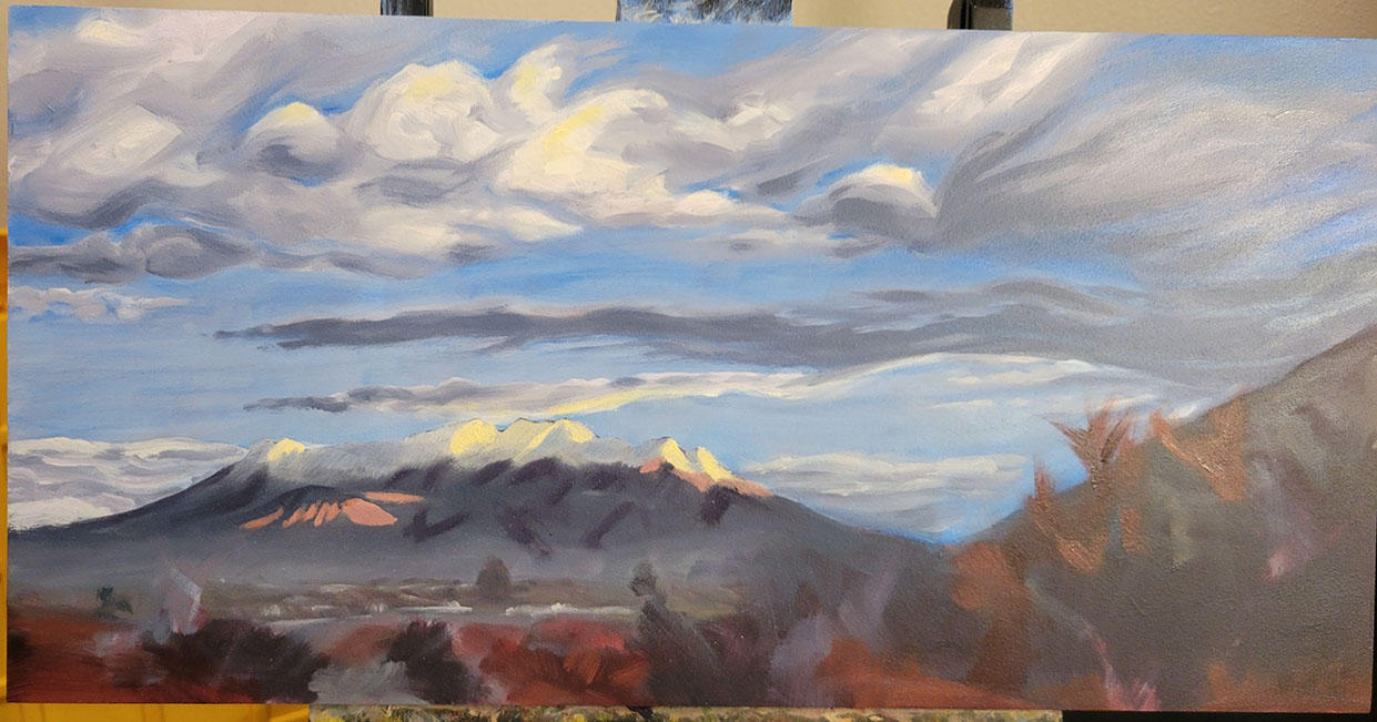
Hey, I got another sunrise piece done! This one is called Timpanogos Dawn. 20x10 oils on panel.
I struggled with the highlights and shadow on the mountain initially, but I'm satisfied with how it is now. Struggle is good, right!?
Hey, I got another sunrise piece done! This one is called Timpanogos Dawn. 20x10 oils on panel.
I struggled with the highlights and shadow on the mountain initially, but I'm satisfied with how it is now. Struggle is good, right!?
Well what do you know?! I finished another piece! This one is "Above Snow Hollow Loop" it is 20x10, oil on board. These are the GPS coordinates: 39.946029, -112.414842.
Snow Hollow Loop is south of Vernon Utah and west of Eureka. Miki and I were out there exploring some little jeep trails last May after a very heavy snow season. Neither of us had been in the area before. There is a reservoir and campground down by the main loop but there are a good dozen or more jeep trails that spur off of it. We explored a handful and left the rest for another time when we are out there again.
One thing that was interesting to see is the grey areas around the snow fields. It seems like the as the snow melts it takes a while for the plants to sprout up and turn things green. So the grey areas are where the plants haven't had enough time to grow yet.
Here are a couple WIP shots and the reference from that day. Enjoy!
Hurray! Another painting completed. This one is titled "Burnt Toast." It is 14x11, Oil on Panel.
This is a fun landmark in the middle of the 7-mile Rim trail in Moab. You have to squeeze your jeep between the three big rocks in the foreground and the jumble of rocks behind them. This landmark is right below Merrimac Butte and right across from Monitor Butte. Those buttes really do remind you of the Civil War battleships.
It is interesting noticing the difference in the rock color of the "Toast" slices from the other boulders around it. I have to assume that they fell from high up on the butte where the layers are darker and redder than those at the lower level around them. I'm not sure if they split when they fell or split from ice and weathering in their current location.
Here are the GPS coordinates: 38.661821, -109.743728 And here is an early WIP and the reference image that I used.
Hey friends! Here is another painting that I completed recently. This one is "Destination Towers." It is 10x20 oils on panel and here are the GPS coordinates: 38.683406, -109.750537
This is an amazing place. This imposing feature marks the end of the challenging parts of the 7 Mile Rim trail in Moab Utah. It is a little ways above the famous "Wipeout Hill" which is always a nail biter for me. It is interesting to see how prominent the different layers of rock are and how distinct the coloring changes from the purple at the top to the redish below. Enjoy!
Sunrise over Rock Canyon - 10x20, oil on panel
Here are the GPS coordinates - 40.241708, -111.733310
A few months ago I was riding by the airport and saw some wispy clouds above the mountains. There wasn't much light yet but I kept my eye on them as I made my way north and west out toward Utah Lake. When I got past the campground, the sky was on fire with pink, purple, orange and yellow. I watched for a minute. It amazes me how quickly the light changes or fades some mornings.
My Cousin and mentor Jenny Richter challenged me to start painting again. So I dusted off my paint box and got going. We would meet at Mary Adams' house and work on different projects as they showed me the nuts and bolts of oils that I had forgotten over the the last few decades.
Currently I am really drawn to the the extra wide format because I feel like it is the best fit for the landscapes that are currently inspiring me. It is amazing how much differently I look at the world around me when I think that I might end up paining it. It helps me see the beauty and awe in nature again.
Here are the paintings that I have created in the last few months (most recent at the top and earliest at the bottom, GPS coordinates of the location included.)